Murfreesboro Outdoors: Greenways, Parks and Trails
Limestone sits close to the surface across Rutherford County, and the forks of the Stones River wind right through Murfreesboro. That shapes the outdoors here: shady river trails, rocky cedar glades that bloom with rare wildflowers in spring, and parks big enough to lose the sound of traffic.
The places below range from paved paths built for strollers and bikes to rocky footpaths where you will want real shoes. Pick one for an hour, or string a few together for a full day outside.
Stones River Greenway
Citywide, along the West Fork of the Stones River · Thompson Lane Trailhead, 2240 N. Thompson Lane, Murfreesboro, TN 37129 (one of 11 trailheads)
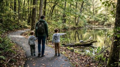
The backbone of the city's greenway system follows the West Fork of the Stones River for about 10.5 paved miles, from Thompson Lane south to Barfield Crescent Park. It winds past limestone outcrops, hardwood bottoms and Civil War sites, through a corridor that herons, owls and deer call home. Eleven trailheads let you hop on almost anywhere, and some add restrooms, bark parks or launches for kayaks and canoes.
Tip: Start at the Thompson Lane Trailhead for river access and a short walk to McFadden's Farm, part of the national battlefield, then head south as far as your legs allow. The pavement suits strollers, bikes and wheelchairs.
More on Murfreesboro.com: Eleven Trailheads, Two Bark Parks, and the Largest Earthen Fort of the Civil War
Barfield Crescent Park
South Murfreesboro · 697 Veterans Pkwy., Murfreesboro, TN 37128
At 430 acres, Barfield is the city's big backyard, and about 275 of those acres are natural area. Roughly 5 miles of hiking trail leave the ball fields behind, winding through oak and hickory woods over limestone outcrops to an overlook on the West Fork. Mountain bike trails, an 18-hole disc golf course and the greenway's southern trailhead round it out, and two playgrounds and plenty of picnic shelters make it an easy all-day base.
Tip: For the wildest stretch, follow the red blazes of the Marshall Knob Trail past the river overlook. Families with little ones can stick to the paved first section that starts at the Wilderness Station.
More on Murfreesboro.com: Barfield Crescent Park · City adds 70 acres to southern border of Barfield Crescent Park
Gateway Island
West College Street · 1875 W. College St., Murfreesboro, TN 37129
This landscaped island off West College Street sits on a well-lit trail that is part of the greenway system, with a gazebo, cascading waterfalls and a lake overlook along the way. It is a favorite for charity walks, photo sessions and birdwatchers, who log it as an eBird hotspot.
Tip: Park at the College Street Trailhead next door, and leave the bread at home: the city asks visitors not to feed the waterfowl. The flat path is easy on little legs and especially pretty at golden hour.
More on Murfreesboro.com: Gateway Island Open House
North Murfreesboro Greenway
Walter Hill, north of town · Walter Hill Trailhead, 5430 Lebanon Road, Murfreesboro, TN 37129
This quieter, stand-alone stretch follows the East Fork of the Stones River for 1.3 shaded miles between the Walter Hill and Central Valley trailheads. Bluffs along the way open up big river views, with benches at two overlooks, and the Walter Hill end has a historic dam and a ramp for small boats. Both trailheads have parking, picnic spots and restrooms.
Tip: Expect a couple of switchbacks and short climbs, unlike the flat main greenway. It is at its best in late fall, when the leaves drop and the river views widen.
More on Murfreesboro.com: Parks & Rec Reopens North Greenway and Walter Hill Park
Flat Rock Cedar Glades and Barrens State Natural Area
East of Murfreesboro · 2423 Factory Road, Murfreesboro, TN 37130
Cedar glades, open patches of thin soil over flat limestone, are a Middle Tennessee specialty, and this 846-acre state natural area protects some of the best. Two linked loops, about 3.4 miles in all, cross glades, barrens and cedar woods where rare plants grow, including Tennessee milk-vetch, Missouri primrose and the federally endangered leafy prairie-clover.
Tip: Spring, roughly April through June, brings the best wildflowers. The path is flat but rocky and can be muddy after rain, the lot is small and there are no restrooms; leashed dogs are welcome.
Sharp Springs Natural Area
Smyrna · 311 Jefferson Pike, Smyrna, TN 37167
Smyrna's largest park covers about 360 acres of Army Corps of Engineers land near Percy Priest Lake, with four catch-and-release ponds and fishing piers, bird blinds, an 18-hole disc golf course and plenty of undeveloped woods. Two trailheads tie it into the Smyrna Greenway, which runs on to the Stewart Creek boat ramp, with signs along the way about local history and wildlife.
Tip: Bring a rod for the ponds or a disc for the course. Dogs can run off leash in Bark Springs Park, the fenced dog park inside, which has separate areas for big and small dogs.
Plan it
Every greenway trailhead has parking, and many add restrooms and water fountains, so a walk rarely takes more planning than choosing the closest one. Low sections along the river can flood after heavy rain, so check city notices before heading out.
Fall color usually peaks later here than in the mountains, often in late October or early November, and spring belongs to the glade wildflowers. Summers run hot and humid, so go early in the day and pack bug spray for the river and glade trails. Park and trailhead access times vary, so check current hours before you go.
More Murfreesboro guides: A History Lover's Day in Murfreesboro: Stones River and Beyond · Downtown Murfreesboro: Where to Eat and Shop Around the Square · A Family Day in Murfreesboro: Museums, Playgrounds and Farm Fun · all guides
Last checked October 2026. Places change: if something in this guide has, tell us at press@j3media.vip and we will update it.